FMD and PPR diseases monitoring and surveillance in Algeria: Application of geographic information system
DOI:
https://doi.org/10.51607/22331360.2023.72.2.142Keywords:
Geographical Information System (GIS), peste des petit ruminants, foot and mouth diseaseAbstract
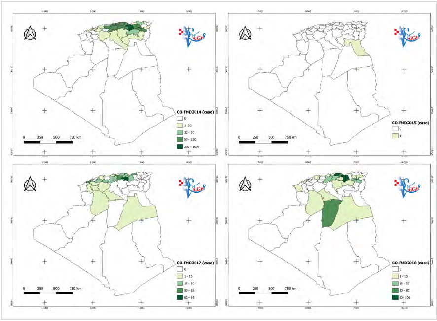
The study aimed to describe the evaluation and implementation of spatial databases that are directly related to animal health in GIS and web-GIS by visualization of the spatio-temporal distribution of animal diseases such as peste des petits ruminants (PPR) and foot-and-mouth disease (FMD) in Algeria. A methodology has been adapted based on the classical steps of GIS and performed using freely available Qgis 3.10. Such methodology can be largely applied to different types of diseases. We have also created a model of website-based «VETALGIS» (Veterinary Algerian GIS) in order to digitalize the veterinary sector and minimize the problem of the lack of data, organize data and facilitate access, which will improve networking and communication between institutions responsible for livestock
disease management. GIS spatial analysis techniques have proven to be a useful tool that can support the decision-making process in planning, implementing and monitoring FMD and PPR control strategies in endemic and high-risk areas.
References
Downloads
Published
Issue
Section
License
Copyright (c) 2023 Ali Dahmani, Nadjet Amina Khelifi-Touhami, Redouane-Larbi Boufeniza, Amira Boufeniza, Asma Chourak, Nassim Ouchene

This work is licensed under a Creative Commons Attribution 4.0 International License.